"Why couldn't you take a 5 month old camping?" -Me after a couple beers at the Tanabata festival
And so, one week later, after a little more convincing we were off. Me, Keenan, Eric, Ninoosh and Bean all jam packed into our car ready to explore a multitude of things on northern Japan's west coast AND camp one night. It was going to be AWESOME. But wait, Bean is only 5 months old, how was this going to be awesome?
I was confident.
Keenan didn't know what to think, but didn't care as long as there was a reward of a campfire, hot dogs and a few beers at the end of it all.
I can't read minds so I'm not exactly sure what Eric and Ninoosh were thinking, probably afraid that this baby-less couple couldn't possibly understand what babies need or have the patience to deal with stopping for feedings and diaper changings and worst of all the constant car crying that's been an ongoing thing with Bean. Probably thinking this was the beginning and the end of our newly formed friendship.
What they didn't understand yet, was other than the camping part, this baby-less lady has had plenty of baby practice. None of those baby-things would deter me. Not sooo long ago my nieces and nephews trained and conditioned me to all things baby, including long road trips...
Yes, this was going to be a great weekend!
Our roles were clear from the start...Me- trip planner/navigator; Keenan- driver; Eric- baby wearer; Ninoosh- everything else baby; Bean- baby.
I had a long list of places I wanted to see, I made somewhat of a mental itinerary and told the driver where to go, we ended up doing a few extras and scraping some things along the way but by the end we had done the following things: saw squid curtains, wandered around Senjojiki Beach, looked upon the Japan Canyon, hiked to some insanely blue ponds, explored an island, canceled our plans to camp, re-initiated our plans to camp, camped, joined the bike portion of a triathlon with our CRV, visited Hirosaki Castle, sat in our car while parked on the sidewalk in front of a restaurant while waiting for an open table, ate "best burgers around" at Pepe's, stopped to see rice art, and finally, managed to keep Bean clean, fed and happy pretty much the whole time.
Read on for the details!
*Map at end of Part 2 post*
After getting ourselves to the west coast, the first goal was to find the squid curtains in Ajigasawa. Fresh caught squid get hung up to dry. After drying they are grilled before eating. They smelled...ummm...well...as yummy dried squid should smell...I suppose...if that's your thing?
GPS coordinates: 40.772605, 140.176220 (yellow marker on map)
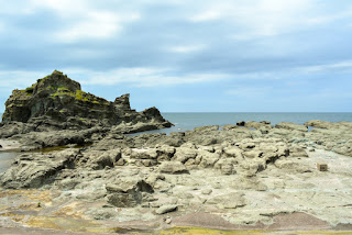
Senjojiki Beach was next. Keenan and I had discovered this "beach" about a month ago. It's actually a huge rock plateau with rocks that look like the waves of the ocean...or at least that's my interpretation. I guess the plateau was actually formed by an earthquake in 1792. Legend has it that the lord of the area once had 1,000 tatami mats laid out on the rocks for a party. We had fun wandering around, Keenan and Bean got their toes wet...only one of them was happy about it...
GPS coordinates: 40.768193, 140.053814 (green marker on map)
Next we stopped by the place we were planning to camp, Yukiaizaki Camping Ground. Beautiful place right on the Sea of Japan.
GPS coordinates: 40.669183, 139.940024
Onward to Juniko, literally "12 lakes," although technically there are 33 lakes/ponds, only 12 could be seen from a mountain peak. This area was formed by a landslide during an earthquake (perhaps that same quake that formed Senjojiki?). The tourist draw to this area is the color of a couple of the lakes. You will see exactly what I mean, amazing. There's also Japan Canyon, named in jest after America's Grand Canyon. We did a short hike to the canyon and then a 3 km roundtrip hike through a beech tree forest to visit a few of the ponds, Bean loved being outside.
GPS coordinates: canyon - 40.557473, 139.964464 & Aoike - 40.560577, 139.984749 (light blue and purple markers on map)
 |
| Japan Canyon! We did not do the hike into the canyon, but even from here the wind was coating us with white dirt...not good for eyes, babies or cameras! |
 |
| Pond of Nietsubo. |
 |
| Eric wears that baby well doesn't he? |
 |
| In awe. |
GPS coordinates: 40.558122, 139.932507 (ship is orange marker on map)
 |
| Love wild hydrangeas! |
I don't know if the penisula has a name...I couldn't find anything on a map.
GPS coordinates: 40.652959, 139.929838 (brown marker on map)
 |
| These creatures were everywhere along the edges of the path...gross. |
 |
| Sidewalk ends and the tunnel up is on the right. |
 |
| Heading up the tunnel... |
 |
| Looking back at Fukaura Town and the path to the island. |
 |
| Cool looking flowers! |
 |
| Awww! I caught her smiling! |
 |
| He could have been a model! |
It was this point in our trip that I checked the weather and saw the forecast was predicting 100% chance of rain and 40-50 mph winds...a huge difference from when I'd checked it first thing this morning. No way we wanted to camp in that kind of weather, especially right by the ocean. So we reluctantly decided we would just head home. We all grumbled about how much we'd been looking forward to hot dogs and campfire and beer as we headed toward home.
But we didn't go home...
Next: Why couldn't you take a 5 month old camping? Part 2


No comments:
Post a Comment